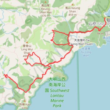
靈浪 靈浪左 狗嶺涌 靈白左右
Islands District Hike
- Distance: 15.5 Km
- Elevation gain: 852 m
- Maximum elevation: 315 m
- Elevation loss: 844 m
- Minimum elevation: 55 m
- Moving time: 4 h 35 m
- Moving speed: 3.4 Km/h
- Maximum speed: 24.0 Km/h
- Total time: 9 h 14 m
- Global speed: 1.7 Km/h
- Date: Sunday, June 02, 2024
Interactive map
GPS track profile
About this GPS track
Name: 靈浪 靈浪左 狗嶺涌 靈白左右 GPS track, route, trail
End: Keung Shan Road, Shek Pik, Islands District, New Territories, Hong Kong, China (22.22817 113.89095)
Coordinates: 22.20731 113.86069 22.22817 113.89142
Topography: Islands District topographic map
Other GPS tracks
Click on a GPS track to view route, its statistics and profile.
羗山東坑 大浪坑左源 羗山北坑左源 凌風石澗
China > Hong Kong > Islands District
Islands District Hike
Distance: 9.5 Km • Elevation gain: 749 m • Maximum elevation: 436 m
深坑瀝小路
China > Hong Kong > Islands District > Luk Wu
Distance: 16.6 Km • Elevation gain: 726 m • Maximum elevation: 462 m
2024 4TUL Half Loop Final
China > Hong Kong > Tsuen Wan District > Chuen Lung Village > Chuen Lung Cha Tau Wo
Distance: 89.0 Km • Elevation gain: 2,267 m • Maximum elevation: 535 m