風琴坑 流白水 螺地墩北坑右
Hong Kong Hike
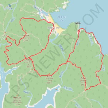
- Distance: 12.6 Km
- Elevation gain: 766 m
- Maximum elevation: 296 m
- Elevation loss: 769 m
- Minimum elevation: 0 m
- Moving time: 3 h 53 m
- Moving speed: 3.2 Km/h
- Maximum speed: 39.0 Km/h
- Total time: 6 h 59 m
- Global speed: 1.8 Km/h
- Date: Sunday, May 26, 2024
Interactive map
GPS track profile
About this GPS track
Name: 風琴坑 流白水 螺地墩北坑右 GPS track, route, trail
Coordinates: 22.38413 114.35990 22.39924 114.38231
Topography: Sai Kung District topographic map
Other GPS tracks
Click on a GPS track to view route, its statistics and profile.
田尾下源 橫頭墩北坑 田鹿石澗左 蛇地 秋楓
China > Hong Kong > Sai Kung District > Tsak Yue Wu
Distance: 21.1 Km • Elevation gain: 811 m • Maximum elevation: 336 m