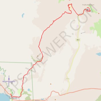
Lac Viti - Lac Mývatn
- Distance: 18.0 Km
- Elevation gain: 202 m
- Maximum elevation: 609 m
- Elevation loss: 499 m
- Minimum elevation: 279 m
- Moving time: 5 h 16 m
- Moving speed: 3.4 Km/h
- Maximum speed: 7.2 Km/h
- Total time: 7 h 50 m
- Global speed: 2.3 Km/h
- Date: Wednesday, July 31, 2019
Interactive map
GPS track profile
About this GPS track
Name: Lac Viti - Lac Mývatn GPS track, route, trail
Start: Kröfluvegur, Þingeyjarsveit, Norðurland eystra, Islande (65.71841 -16.75536)
End: Reynihlíð, Reykjahlíð, Þingeyjarsveit, Norðurland eystra, Islande (65.64492 -16.91408)
Coordinates: 65.64194 -16.91408 65.72226 -16.74813
Other GPS tracks
Click on a GPS track to view route, its statistics and profile.
Lac Viti - Lac Mývatn
Distance: 18.0 Km • Elevation gain: 201 m • Maximum elevation: 609 m