Mont Choungui
- Distance: 3.3 Km
- Elevation gain: 254 m
- Maximum elevation: 504 m
- Elevation loss: 254 m
- Minimum elevation: 282 m
Interactive map
GPS track profile
About this GPS track
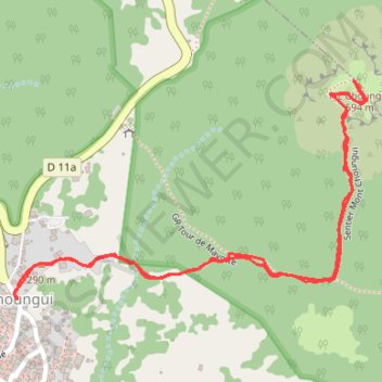
Name: Mont Choungui GPS track, route, trail
Start: Rue Tsingo N'Drilé, Choungui, Kani-Kéli, Mayotte, 97625, France (-12.96131 45.12690)
End: Rue Tsingo N'Drilé, Choungui, Kani-Kéli, Mayotte, 97625, France (-12.96133 45.12688)
Coordinates: -12.96133 45.12681 -12.95667 45.13450
Other GPS tracks
Click on a GPS track to view route, its statistics and profile.