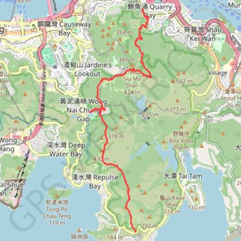
Wilson Trail
#Hike
- Distance: 13.1 Km
- Elevation gain: 1,032 m
- Maximum elevation: 410 m
- Elevation loss: 972 m
- Minimum elevation: 26 m
Interactive map
GPS track profile
About this GPS track
Name: Wilson Trail GPS track, route, trail
Coordinates: 22.22368 114.19483 22.28604 114.21338
Topography: Hong Kong Island topographic map
Other GPS tracks
Click on a GPS track to view route, its statistics and profile.
雙潭渣大
China > Hong Kong > Hong Kong Island
Distance: 6.8 Km • Elevation gain: 353 m • Maximum elevation: 305 m
Hong Kong island ride
China > Hong Kong > Hong Kong Island
#Bike
Distance: 61.8 Km • Elevation gain: 2,152 m • Maximum elevation: 505 m
Wilson Trail Full Route
China > Hong Kong > Hong Kong Island
Distance: 81.2 Km • Elevation gain: 4,430 m • Maximum elevation: 613 m
Jardine's Lookout
China > Hong Kong > Hong Kong Island
#Hike
Distance: 6.1 Km • Elevation gain: 350 m • Maximum elevation: 410 m
Trail Planner Map
China > Hong Kong > Hong Kong Island
Distance: 20.3 Km • Elevation gain: 1,151 m • Maximum elevation: 423 m
Parview - Mont Butler - Reservoirs - Repulse Bay
Chine > Hong Kong > Île de Hong Kong
Randonnée pédestre. En aller simple. #Randonnée
Distance: 8.4 Km • Elevation gain: 382 m • Maximum elevation: 410 m