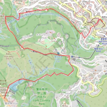
Central Hong Kong - Pok Fu Lam Country Park
#Hike
- Distance: 7.4 Km
- Elevation gain: 431 m
- Maximum elevation: 401 m
- Elevation loss: 352 m
- Minimum elevation: 61 m
Interactive map
GPS track profile
About this GPS track
Name: Central Hong Kong - Pok Fu Lam Country Park GPS track, route, trail
Coordinates: 22.26261 114.13528 22.28089 114.15692
Topography: Hong Kong Island topographic map
Other GPS tracks
Click on a GPS track to view route, its statistics and profile.
HK dino
China > Hong Kong > Hong Kong Island
Loop hike from Kennedy Town via Lung Fu Shan, High West, Victoria Peak, Pok Fu Lam Reservoir and Mount Davis in the Lung Fu Shan Country Park and the Pok Fu Lam Country Park. #Hike #Loop #Nature #Mountain #Forest #Sea #Pacific #Ocean #Park
Distance: 24.4 Km • Elevation gain: 1,325 m • Maximum elevation: 529 m
Hong Kong island ride
China > Hong Kong > Hong Kong Island
#Bike
Distance: 61.8 Km • Elevation gain: 2,152 m • Maximum elevation: 505 m
Wilson Trail Full Route
China > Hong Kong > Hong Kong Island
Distance: 81.2 Km • Elevation gain: 4,430 m • Maximum elevation: 613 m
Trail Planner Map
China > Hong Kong > Hong Kong Island
Distance: 20.3 Km • Elevation gain: 1,151 m • Maximum elevation: 423 m