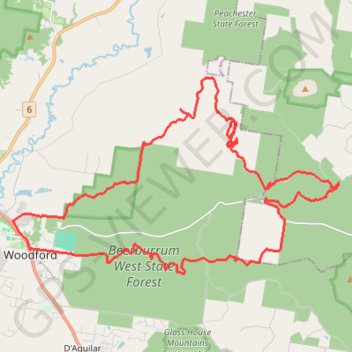
Woodford - Beerburrum West State Forest
#MTB #Loop #Beerburrum
- Distance: 46.3 Km
- Elevation gain: 697 m
- Maximum elevation: 212 m
- Elevation loss: 698 m
- Minimum elevation: 47 m
Interactive map
GPS track profile
About this GPS track
Name: Woodford - Beerburrum West State Forest GPS track, route, trail
End: 83, Archer Street, Woodford, City of Moreton Bay, Queensland, 4514, Australia (-26.95322 152.77770)
Coordinates: -26.96161 152.77104 -26.89346 152.89781
Other GPS tracks
Click on a GPS track to view route, its statistics and profile.