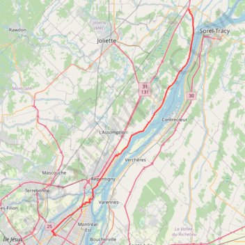
Montréal - Berthierville
#Bike
- Distance: 71.1 Km
- Elevation gain: 133 m
- Maximum elevation: 41 m
- Elevation loss: 159 m
- Minimum elevation: 6 m
Interactive map
GPS track profile
About this GPS track
Name: Montréal - Berthierville GPS track, route, trail
End: 760, Rue Gadoury, Berthierville, D'Autray, Lanaudière, Quebec, J0K 1A0, Canada (46.08779 -73.19405)
Coordinates: 45.61146 -73.60744 46.08779 -73.18046
Other GPS tracks
Click on a GPS track to view route, its statistics and profile.
Montréal - Lanoraie
Canada > Quebec > Urban agglomeration of Montreal > Montreal
Saint Lawrence River. #Bike #Montréal #Lanoraie #SaintLawrence
Distance: 70.1 Km • Elevation gain: 181 m • Maximum elevation: 52 m
Circuit Violet
Canada > Quebec > Matawinie > Rawdon
Distance: 95.5 Km • Elevation gain: 942 m • Maximum elevation: 273 m
Lanoraie - Trois-Rivières
Canada > Quebec > D'Autray > Lanoraie
Saint Lawrence River. #Bike #Lanoraie #TroisRivières #SaintLawrence
Distance: 71.5 Km • Elevation gain: 122 m • Maximum elevation: 21 m
Pierreville - Leclercville
Canada > Quebec > Urban agglomeration of Montreal > Montreal
#Bike #Pierreville #Leclercville #Atlantic
Distance: 120.8 Km • Elevation gain: 324 m • Maximum elevation: 36 m
Berthierville - Trois-Rivières
Canada > Quebec > D'Autray > Berthierville
#Bike
Distance: 72.7 Km • Elevation gain: 161 m • Maximum elevation: 41 m