Ten_78_Paisaje Lunar
- Distance: 13.0 Km
- Elevation gain: 660 m
- Maximum elevation: 1,961 m
- Elevation loss: 660 m
- Minimum elevation: 1,378 m
Interactive map
GPS track profile
About this GPS track
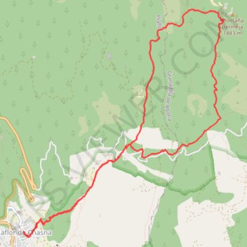
Name: Ten_78_Paisaje Lunar GPS track, route, trail
Coordinates: 28.15831 -16.63634 28.19063 -16.60420
Other GPS tracks
Click on a GPS track to view route, its statistics and profile.
LONG TRAIL GR - 131 TENERIFE (CANARY ISLANDS) GR131 GR 131|trackspotting.com
Spain > El Rosario > La Esperanza
Distance: 87.7 Km • Elevation gain: 4,437 m • Maximum elevation: 2,404 m