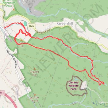
Sugarloaf Hill - Chambers Gully Loop
Cleland Conservation Park. #Hike #Loop #Sugarloaf #Chambers #Cleland
- Distance: 11.5 Km
- Elevation gain: 502 m
- Maximum elevation: 484 m
- Elevation loss: 548 m
- Minimum elevation: 182 m
- Moving time: 1 h 28 m
- Moving speed: 7.9 Km/h
- Maximum speed: 16.8 Km/h
- Total time: 1 h 28 m
- Global speed: 7.8 Km/h
- Date: Friday, January 24, 2020
Interactive map
GPS track profile
About this GPS track
Name: Sugarloaf Hill - Chambers Gully Loop GPS track, route, trail
Coordinates: -34.96623 138.67233 -34.94978 138.70433
Other GPS tracks
Click on a GPS track to view route, its statistics and profile.