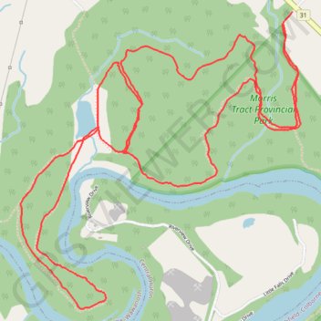
Morris Tract Provincial Nature Reserve - Maitland River
#Hike #Loop #MorrisTract #Maitland
- Distance: 9.3 Km
- Elevation gain: 180 m
- Maximum elevation: 268 m
- Elevation loss: 178 m
- Minimum elevation: 206 m
Interactive map
GPS track profile
About this GPS track
Name: Morris Tract Provincial Nature Reserve - Maitland River GPS track, route, trail
Coordinates: 43.71803 -81.65976 43.73270 -81.64064
Other GPS tracks
Click on a GPS track to view route, its statistics and profile.
Morris Tract Provincial Nature Reserve - Maitland River
Canada > Ontario > Huron County > Ashfield–Colborne–Wawanosh
Lake Huron. #Hike #Loop #MorrisTract #Huron
Distance: 23.7 Km • Elevation gain: 325 m • Maximum elevation: 276 m