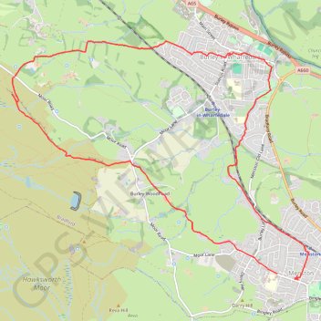
Burley Woodhead walk (foot)
Menston - Burley Woodhead - Burley - Menston
- Distance: 12.1 Km
- Elevation gain: 253 m
- Maximum elevation: 299 m
- Elevation loss: 258 m
- Minimum elevation: 71 m
- Moving time: 2 h 58 m
- Moving speed: 4.1 Km/h
- Maximum speed: 7.5 Km/h
- Total time: 4 h 9 m
- Global speed: 2.9 Km/h
- Date: Thursday, May 02, 2024
Interactive map
GPS track profile
About this GPS track
Name: Burley Woodhead walk (foot) GPS track, route, trail
Coordinates: 53.88891 -1.78991 53.91465 -1.73560