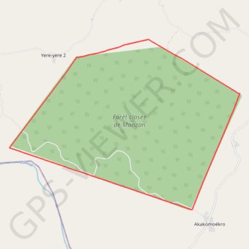
FC MANZAN
Limite_FC.SHP
- Distance: 26.8 Km
- Elevation gain: 283 m
- Maximum elevation: 237 m
- Elevation loss: 283 m
- Minimum elevation: 112 m
Interactive map
GPS track profile
About this GPS track
Name: FC MANZAN GPS track, route, trail
Start: Akakomoékro, Bettié, Indénié-Djuablin, Comoé, Côte d’Ivoire (6.17750 -3.36269)
End: Akakomoékro, Bettié, Indénié-Djuablin, Comoé, Côte d’Ivoire (6.17750 -3.36269)
Coordinates: 6.17750 -3.43507 6.24456 -3.34387
Other GPS tracks
Click on a GPS track to view route, its statistics and profile.
P 103-96-20
Côte d’Ivoire > Comoé > Bettié > Akakomoékro
103-96-20.shp
Distance: 1.1 Km • Elevation gain: 20 m • Maximum elevation: 134 m