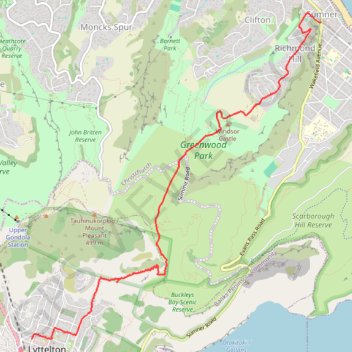
Lyttelton to Sumner Walk
Hike from Lyttelton to Sumner via Chalmers Track, Mount Pleasant Bluffs Track, Summit Road and Windsor Castle in the Tauhinu-Korokio Scenic Reserve and the Greenwood Park. #Hike #Walk #Nature #Mountain #Park #Forest #Sea #Pacific #Ocean
- Distance: 7.1 Km
- Elevation gain: 411 m
- Maximum elevation: 418 m
- Elevation loss: 438 m
- Minimum elevation: 4 m
- Moving time: 2 h 1 m
- Moving speed: 3.5 Km/h
- Maximum speed: 5.4 Km/h
- Total time: 2 h 12 m
- Global speed: 3.2 Km/h
- Date: Saturday, February 24, 2024
Interactive map
GPS track profile
About this GPS track
Name: Lyttelton to Sumner Walk GPS track, route, trail
Coordinates: -43.60147 172.71840 -43.56843 172.75890
Other GPS tracks
Click on a GPS track to view route, its statistics and profile.