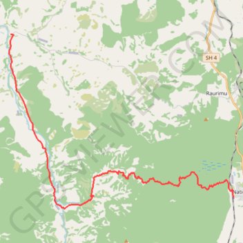
Fishers Track
- Distance: 27.5 Km
- Elevation gain: 426 m
- Maximum elevation: 850 m
- Elevation loss: 1,022 m
- Minimum elevation: 197 m
- Moving time: 1 h 25 m
- Moving speed: 19.3 Km/h
- Maximum speed: 51.4 Km/h
- Total time: 1 h 34 m
- Global speed: 17.4 Km/h
- Date: Friday, April 26, 2024
Interactive map
GPS track profile
About this GPS track
Name: Fishers Track GPS track, route, trail
End: Oio Road, Ruapehu District, Manawatū-Whanganui, 3990, New Zealand (-39.09277 175.24788)
Coordinates: -39.18154 175.24658 -39.09275 175.39388
Other GPS tracks
Click on a GPS track to view route, its statistics and profile.