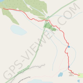
#2c Aasgard Pass, 1m, 2250ft
- Distance: 1.7 Km
- Elevation gain: 677 m
- Maximum elevation: 2,382 m
- Elevation loss: 2 m
- Minimum elevation: 1,705 m
Interactive map
GPS track profile
About this GPS track
Name: #2c Aasgard Pass, 1m, 2250ft GPS track, route, trail
Start: Aasgard Pass Trail, Chelan County, Washington, United States (47.48751 -120.83322)
Coordinates: 47.48030 -120.83322 47.48751 -120.82110
Other GPS tracks
Click on a GPS track to view route, its statistics and profile.
Enchantmentpeak on GPSies.com
United States > Washington > Chelan County
Distance: 12.3 Km • Elevation gain: 1,777 m • Maximum elevation: 2,572 m
Northern part of the Pacific Crest Trail (PCT)
United States > Oregon > Klamath County
Hike on the Pacific Crest National Scenic Trail from Crater Lake to Canada Border through Oregon and Washington along the Sierra Nevada and Cascade mountain ranges. #Hike #Mountain #SierraNevada #Cascade #Nature #Forest #Park #PCT
Distance: 1,198.3 Km • Elevation gain: 44,308 m • Maximum elevation: 2,307 m