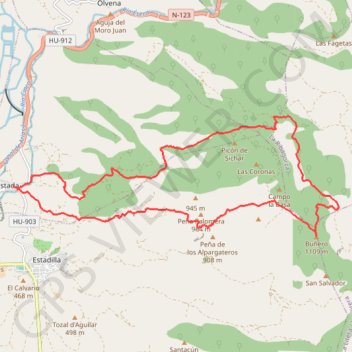
Estada-pico Buñero
Randonnée en boucle depuis Estada. #Randonnée #Boucle #Aragon #Pyrénées #Montagne #Nature
- Distance: 20.7 Km
- Elevation gain: 919 m
- Maximum elevation: 1,103 m
- Elevation loss: 918 m
- Minimum elevation: 370 m
- Moving time: 3 h 45 m
- Moving speed: 5.5 Km/h
- Maximum speed: 7.6 Km/h
- Total time: 4 h 22 m
- Global speed: 4.8 Km/h
- Date: Saturday, March 29, 2014
Interactive map
GPS track profile
About this GPS track
Name: Estada-pico Buñero GPS track, route, trail
Start: Estada, Somontano de Barbastro, Huesca, Aragon, 22423, Espagne (42.07167 0.23533)
End: Estada, Somontano de Barbastro, Huesca, Aragon, 22423, Espagne (42.07165 0.23545)
Coordinates: 42.06204 0.23533 42.08526 0.31994
Other GPS tracks
Click on a GPS track to view route, its statistics and profile.
Southern section — European Divide Trail
France > Auvergne-Rhône-Alpes > Drôme > Valence
Distance: 2,423.8 Km • Elevation gain: 42,375 m • Maximum elevation: 2,005 m
Bardenas_Andorre_Mediterranee
Bardenas_Andorre_Mediterranee
Distance: 1,011.0 Km • Elevation gain: 24,504 m • Maximum elevation: 2,214 m
1 LUCENA - MONTPELLIER
Distance: 2,964.4 Km • Elevation gain: 29,500 m • Maximum elevation: 1,048 m
1 LUCENA - MONTPELLIER
Espagne > Andalousie > Lucena
Distance: 2,964.4 Km • Elevation gain: 29,500 m • Maximum elevation: 1,048 m
Stage 26: Valence to Saint-Jean-de-Fos — European Divide Trail
France > Auvergne-Rhône-Alpes > Drôme > Valence
Distance: 2,423.8 Km • Elevation gain: 42,375 m • Maximum elevation: 2,005 m
Stage 26: Valence to Saint-Jean-de-Fos — European Divide Trail
France > Auvergne-Rhône-Alpes > Drôme > Valence
Distance: 1,629.8 Km • Elevation gain: 30,841 m • Maximum elevation: 2,005 m
De Villeneuve-sur-Lot à Guimarães
France > Nouvelle-Aquitaine > Lot-et-Garonne > Villeneuve-sur-Lot
Distance: 2,024.3 Km • Elevation gain: 22,121 m • Maximum elevation: 1,339 m