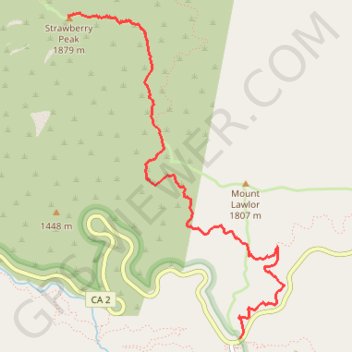
Strawberry Peak
Hike from Red Box Gap to Strawberry Peak via Barley Flats Truck Trail and Strawberry Peak Trail in the San Gabriel Mountains National Monument and the Angeles National Forest. #Hike #Mountain #Nature #Forest #Angeles
- Distance: 5.7 Km
- Elevation gain: 696 m
- Maximum elevation: 1,864 m
- Elevation loss: 251 m
- Minimum elevation: 1,418 m
Interactive map
GPS track profile
About this GPS track
Name: Strawberry Peak GPS track, route, trail
Start: Barley Flats Truck Trail, Los Angeles County, California, 91023, United States (34.25877 -118.10440)
End: Colby Canyon Trail, Los Angeles County, California, United States (34.28350 -118.12043)
Coordinates: 34.25877 -118.12043 34.28375 -118.10035
Other GPS tracks
Click on a GPS track to view route, its statistics and profile.