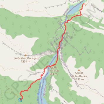
Mont Rebei
Randonnée pédestre. En aller simple. #Randonnée #Lérida #Pyrénées #Montagne #Aragon #Nature
- Distance: 8.8 Km
- Elevation gain: 620 m
- Maximum elevation: 771 m
- Elevation loss: 869 m
- Minimum elevation: 482 m
- Moving time: 2 h 47 m
- Moving speed: 3.1 Km/h
- Maximum speed: 22.8 Km/h
- Total time: 3 h 29 m
- Global speed: 2.5 Km/h
- Date: Saturday, May 16, 2015
Interactive map
GPS track profile
About this GPS track
Name: Mont Rebei GPS track, route, trail
Coordinates: 42.05199 0.65534 42.09753 0.69626
Other GPS tracks
Click on a GPS track to view route, its statistics and profile.
Southern section — European Divide Trail
France > Auvergne-Rhône-Alpes > Drôme > Valence
Distance: 2,423.8 Km • Elevation gain: 42,375 m • Maximum elevation: 2,005 m
1 LUCENA - MONTPELLIER
Distance: 2,964.4 Km • Elevation gain: 29,500 m • Maximum elevation: 1,048 m
Bardenas_Andorre_Mediterranee
Bardenas_Andorre_Mediterranee
Distance: 1,011.0 Km • Elevation gain: 24,504 m • Maximum elevation: 2,214 m
1 LUCENA - MONTPELLIER
Espagne > Andalousie > Lucena
Distance: 2,964.4 Km • Elevation gain: 29,500 m • Maximum elevation: 1,048 m
Stage 26: Valence to Saint-Jean-de-Fos — European Divide Trail
France > Auvergne-Rhône-Alpes > Drôme > Valence
Distance: 2,423.8 Km • Elevation gain: 42,375 m • Maximum elevation: 2,005 m
Stage 26: Valence to Saint-Jean-de-Fos — European Divide Trail
France > Auvergne-Rhône-Alpes > Drôme > Valence
Distance: 1,629.8 Km • Elevation gain: 30,841 m • Maximum elevation: 2,005 m
De Villeneuve-sur-Lot à Guimarães
France > Nouvelle-Aquitaine > Lot-et-Garonne > Villeneuve-sur-Lot
Distance: 2,024.3 Km • Elevation gain: 22,121 m • Maximum elevation: 1,339 m