Zwick's Island Park
- Distance: 0.9 Km
- Elevation gain: 5 m
- Maximum elevation: 81 m
- Elevation loss: 3 m
- Minimum elevation: 76 m
- Moving time: 15 m 45 s
- Moving speed: 3.3 Km/h
- Maximum speed: 6.5 Km/h
- Total time: 15 m 45 s
- Global speed: 3.3 Km/h
- Date: Thursday, May 02, 2024
Interactive map
GPS track profile
About this GPS track
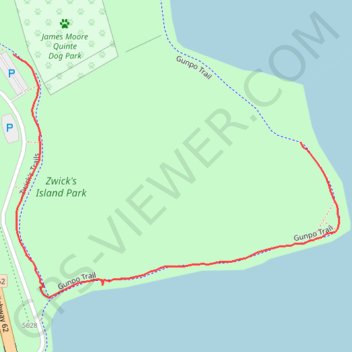
Name: Zwick's Island Park GPS track, route, trail
Start: Gunpo Trail, Belleville, Central Ontario, Ontario, K8N 1B5, Canada (44.15355 -77.38325)
End: Zwick's Trails, Belleville, Central Ontario, Ontario, K8N 1B5, Canada (44.15456 -77.38784)
Coordinates: 44.15177 -77.38784 44.15456 -77.38264
Other GPS tracks
Click on a GPS track to view route, its statistics and profile.
Belleville - Kingston
Canada > Ontario > Belleville > Belleville
#Bike
Distance: 92.7 Km • Elevation gain: 394 m • Maximum elevation: 115 m
Cobourg - Belleville
Canada > Ontario > Northumberland County > Cobourg
#Bike
Distance: 81.5 Km • Elevation gain: 286 m • Maximum elevation: 118 m