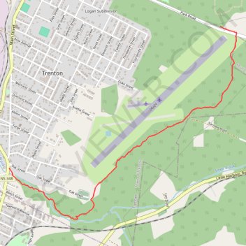
Trenton Park - Airport Route
Purple Route
- Distance: 3.5 Km
- Elevation gain: 37 m
- Maximum elevation: 100 m
- Elevation loss: 94 m
- Minimum elevation: 8 m
- Moving time: 50 m 18 s
- Moving speed: 4.2 Km/h
- Maximum speed: 5.8 Km/h
- Total time: 52 m 28 s
- Global speed: 4.0 Km/h
- Date: Thursday, May 02, 2024
Interactive map
GPS track profile
About this GPS track
Name: Trenton Park - Airport Route GPS track, route, trail
End: 34, Main Street, Town of Trenton, Pictou County, Nova Scotia, B2H 1Y3, Canada (45.60646 -62.63797)
Coordinates: 45.60246 -62.63797 45.61766 -62.61233
Other GPS tracks
Click on a GPS track to view route, its statistics and profile.
Pictou - Antigonish
Canada > Nova Scotia > Town of Pictou > Pictou
Gulf of Saint Lawrence. #Bike #Pictou #Antigonish #SaintLawrence #Atlantic
Distance: 101.8 Km • Elevation gain: 808 m • Maximum elevation: 147 m
Pictou - Antigonish
Canada > Nova Scotia > Town of Pictou > Pictou
#Bike #Pictou #Antigonish
Distance: 74.3 Km • Elevation gain: 744 m • Maximum elevation: 154 m