TRK Cascade FFRP AR
Grde cascade aller retour
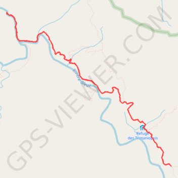
- Distance: 15.4 Km
- Elevation gain: 603 m
- Maximum elevation: 418 m
- Elevation loss: 603 m
- Minimum elevation: 229 m
Interactive map
GPS track profile
About this GPS track
Name: TRK Cascade FFRP AR GPS track, route, trail
Coordinates: -22.09459 166.60282 -22.06279 166.63950
Other GPS tracks
Click on a GPS track to view route, its statistics and profile.
GR NC1 - Etape 6 - Du refuge des Tristaniopsis au refuge de la Mine Soleil
France > Province Sud > Yaté
Distance: 15.3 Km • Elevation gain: 1,239 m • Maximum elevation: 1,113 m