Rota Vicentina : étape 1
Interactive map
GPS track profile
About this GPS track
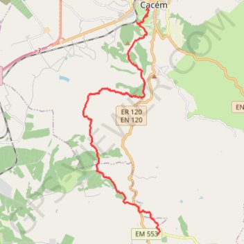
Name: Rota Vicentina : étape 1 GPS track, route, trail
Coordinates: 37.92251 -8.72996 38.01434 -8.69032
Other GPS tracks
Click on a GPS track to view route, its statistics and profile.
Southern section — European Divide Trail
France > Auvergne-Rhône-Alpes > Drôme > Valence
Distance: 2,423.8 Km • Elevation gain: 42,375 m • Maximum elevation: 2,005 m
Eurovelo 01 Spain + Portugal
France > Nouvelle-Aquitaine > Pyrénées-Atlantiques > Hendaye
Distance: 3,107.2 Km • Elevation gain: 30,592 m • Maximum elevation: 1,503 m
Rota Vicentina - Chemin historique - Étape 1
Portugal > Setúbal > Santiago do Cacém
Santiago do Cacém » Vale Seco
Distance: 17.6 Km • Elevation gain: 360 m • Maximum elevation: 276 m
Stage 26: Valence to Saint-Jean-de-Fos — European Divide Trail
France > Auvergne-Rhône-Alpes > Drôme > Valence
Distance: 2,423.8 Km • Elevation gain: 42,375 m • Maximum elevation: 2,005 m
Stage 26: Valence to Saint-Jean-de-Fos — European Divide Trail
Distance: 859.0 Km • Elevation gain: 16,438 m • Maximum elevation: 1,490 m