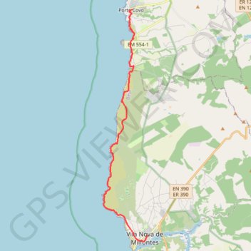
Rota Vicentina - Sentier des pêcheurs - Étape 1
Porto Covo » Vila Nova de Milfontes
- Distance: 19.5 Km
- Elevation gain: 403 m
- Maximum elevation: 48 m
- Elevation loss: 398 m
- Minimum elevation: 0 m
Interactive map
GPS track profile
About this GPS track
Name: Rota Vicentina - Sentier des pêcheurs - Étape 1 GPS track, route, trail
Start: Rua Vasco da Gama, Porto Covo, Sines, Setúbal, 7520-437, Portugal (37.85191 -8.79100)
End: Rua António Mantas, Vila Nova de Milfontes, Odemira, Beja, 7645-221, Portugal (37.72610 -8.78018)
Coordinates: 37.72311 -8.81107 37.85191 -8.78018
Other GPS tracks
Click on a GPS track to view route, its statistics and profile.
Southern section — European Divide Trail
France > Auvergne-Rhône-Alpes > Drôme > Valence
Distance: 2,423.8 Km • Elevation gain: 42,375 m • Maximum elevation: 2,005 m
Eurovelo 01 Spain + Portugal
France > Nouvelle-Aquitaine > Pyrénées-Atlantiques > Hendaye
Distance: 3,107.2 Km • Elevation gain: 30,592 m • Maximum elevation: 1,503 m
Stage 26: Valence to Saint-Jean-de-Fos — European Divide Trail
France > Auvergne-Rhône-Alpes > Drôme > Valence
Distance: 2,423.8 Km • Elevation gain: 42,375 m • Maximum elevation: 2,005 m
Rota Vicentina - Sentier des pêcheurs - Étape 2
Portugal > Beja > Vila Nova de Milfontes
Vila Nova de Milfontes » Almograve
Distance: 15.1 Km • Elevation gain: 259 m • Maximum elevation: 44 m
MaRotaVicentina
Portugal > Beja > Odemira > Bemposta de Cima
Distance: 137.1 Km • Elevation gain: 2,639 m • Maximum elevation: 289 m
Stage 26: Valence to Saint-Jean-de-Fos — European Divide Trail
Distance: 859.0 Km • Elevation gain: 16,438 m • Maximum elevation: 1,490 m
Vila do Bispo -> Distrito 4 (495,2 km)
Distance: 1,306.4 Km • Elevation gain: 23,128 m • Maximum elevation: 2,134 m
TP00 STorp-PCovo
Distance: 9.7 Km • Elevation gain: 100 m • Maximum elevation: 27 m