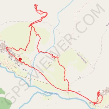
Tour Annapurna - Jour 07 - Manang - Manang
Randonnée en boucle depuis Bhakra. #Randonnée #Boucle
- Distance: 9.6 Km
- Elevation gain: 804 m
- Maximum elevation: 4,054 m
- Elevation loss: 800 m
- Minimum elevation: 3,471 m
- Moving time: 3 h 28 m
- Moving speed: 2.7 Km/h
- Maximum speed: 10.4 Km/h
- Total time: 5 h 45 m
- Global speed: 1.7 Km/h
- Date: Sunday, April 06, 2014
Interactive map
GPS track profile
About this GPS track
Name: Tour Annapurna - Jour 07 - Manang - Manang GPS track, route, trail
Coordinates: 28.65678 84.02263 28.67431 84.04176
Other GPS tracks
Click on a GPS track to view route, its statistics and profile.
Annapurna - Example
Népal > Gandaki > मनाङ > Dharapani
Distance: 167.6 Km • Elevation gain: 12,204 m • Maximum elevation: 6,020 m