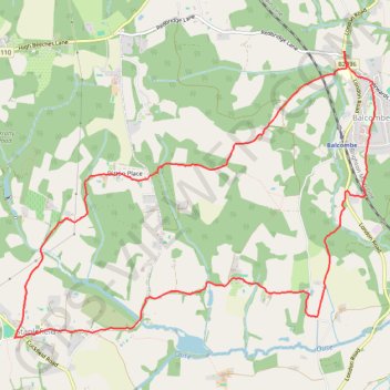
Balcombe to Staplefield Loop
Loop hike from Balcombe to Staplefield via Balcombe Recreation Ground, Kemps Farm, Whitethroat Lane, Brantridge Lane, Tanyard Lane, Ditton Place and Westup Road in the High Weald National Landscape. #Hike #Loop #Countryside #Nature #Forest
- Distance: 12.4 Km
- Elevation gain: 251 m
- Maximum elevation: 141 m
- Elevation loss: 252 m
- Minimum elevation: 59 m
- Moving time: 2 h 40 m
- Moving speed: 4.6 Km/h
- Maximum speed: 7.5 Km/h
- Total time: 3 h 17 m
- Global speed: 3.8 Km/h
- Date: Tuesday, February 27, 2024
Interactive map
GPS track profile
About this GPS track
Name: Balcombe to Staplefield Loop GPS track, route, trail
Coordinates: 51.03806 -0.18232 51.06306 -0.13240
Other GPS tracks
Click on a GPS track to view route, its statistics and profile.
French Divide
France > Hauts-de-France > Nord > Bray-Dunes
Traversez la France du nord au sud sur 2200 Km de sentiers, chemins et petites routes... Magique ! Vous connaissez la mythique Great Divide ? La French Divide est elle aussi en train de devenir une grande classique des traversées en bikepacking et sans assistance !
Distance: 2,215.9 Km • Elevation gain: 33,578 m • Maximum elevation: 1,449 m
Newhaven Londres
Royaume-Uni > Angleterre > Cité de Londres
Vélo. En aller simple entre Londres et Newhaven. #Vélo
Distance: 155.6 Km • Elevation gain: 1,139 m • Maximum elevation: 202 m