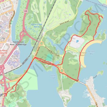
Pelham Bay Park Loop
Loop hike through Pelham Bay Park via Hutchinson River, Orchard Beach and Hunter Island. #Hike #Loop #Nature #Forest #Sea #Atlantic #Ocean #Beach #Island #River #Park
- Distance: 13.1 Km
- Elevation gain: 104 m
- Maximum elevation: 21 m
- Elevation loss: 101 m
- Minimum elevation: -2 m
- Moving time: 2 h 58 m
- Moving speed: 4.4 Km/h
- Maximum speed: 7.6 Km/h
- Total time: 3 h 38 m
- Global speed: 3.6 Km/h
- Date: Sunday, March 15, 2020
Interactive map
GPS track profile
About this GPS track
Name: Pelham Bay Park Loop GPS track, route, trail
Coordinates: 40.85210 -73.82685 40.87968 -73.78461
Other GPS tracks
Click on a GPS track to view route, its statistics and profile.
Montréal - New York
Canada > Québec > Agglomération de Montréal > Montréal
Distance: 637.3 Km • Elevation gain: 4,134 m • Maximum elevation: 301 m