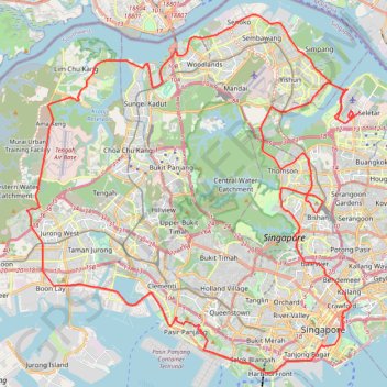
Directions from Duck Tour Ramp to Marina Boulevard, Singapore
- Distance: 105.3 Km
- Elevation gain: 812 m
- Maximum elevation: 51 m
- Elevation loss: 812 m
- Minimum elevation: -4 m
Interactive map
GPS track profile
About this GPS track
Name: Directions from Duck Tour Ramp to Marina Boulevard, Singapore GPS track, route, trail
Start: Marina Promenade, Tanjong Rhu, Kallang, Singapore, Central, 437440, Singapore (1.29657 103.86389)
End: Marina Promenade, Tanjong Rhu, Kallang, Singapore, Central, 437440, Singapore (1.29657 103.86389)
Coordinates: 1.26559 103.68782 1.46409 103.87231
Topography: Singapore topographic map
Other GPS tracks
Click on a GPS track to view route, its statistics and profile.
The Green Corridor - Singapore
Singapore > Northwest > Singapore
#Hike
Distance: 22.3 Km • Elevation gain: 167 m • Maximum elevation: 44 m
Labrador Park
Singapore > Central > Singapore
#Hike
Distance: 8.0 Km • Elevation gain: 91 m • Maximum elevation: 27 m
Bukit Timah Hill - MacRitchie Reservoir
Singapore > Southwest > Singapore
#Hike
Distance: 14.8 Km • Elevation gain: 290 m • Maximum elevation: 167 m
Singapore East Coast Park
Singapore > Southeast > Singapore
#Hike
Distance: 12.6 Km • Elevation gain: 79 m • Maximum elevation: 22 m
MacRitchie Reservoir and TreeTop Walk Loop
Distance: 12.3 Km • Elevation gain: 207 m • Maximum elevation: 89 m
Morning Run
Singapore > Southeast > Singapore
Distance: 13.6 Km • Elevation gain: 166 m • Maximum elevation: 21 m
Singapore Botanical Gardens
Distance: 10.6 Km • Elevation gain: 161 m • Maximum elevation: 40 m
Kualanamu International Airport to Jakarta, Indonesia
Indonésie > Sumatra du Nord > Deli Serdang > Beringin
Distance: 1,809.2 Km • Elevation gain: 10,977 m • Maximum elevation: 125 m
Singapore Botanical Gardens
Singapore > Central > Singapore
Distance: 10.6 Km • Elevation gain: 161 m • Maximum elevation: 40 m
Sungei Buloh Wetland Route
Singapore > Southwest > Singapore
Enjoy the tranquility and serenity of the mangrove habitat is through Route 1. This route goes around the two main ponds and gives a good introduction to the Reserve and the birds of Sungei Buloh, especially during the migratory season from September to March From https://www.aussiebushwalking.com/overseas/sungei-buloh-wetland-route-1
Distance: 2.6 Km • Elevation gain: 16 m • Maximum elevation: 9 m
Singapore Botanical Gardens.gpx
Singapore > Central > Singapore
Distance: 10.6 Km • Elevation gain: 161 m • Maximum elevation: 40 m