Faja do ouvidor
Randonnée pédestre. En aller simple. #Randonnée
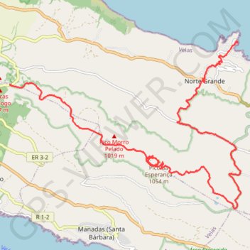
- Distance: 18.4 Km
- Elevation gain: 417 m
- Maximum elevation: 1,039 m
- Elevation loss: 1,199 m
- Minimum elevation: 7 m
- Moving time: 5 h 47 m
- Moving speed: 3.2 Km/h
- Maximum speed: 12.0 Km/h
- Total time: 6 h 59 m
- Global speed: 2.6 Km/h
- Date: Monday, July 19, 2010
Interactive map
GPS track profile
About this GPS track
Name: Faja do ouvidor GPS track, route, trail
Start: ER 3-2, Urzelina (São Mateus), Velas, Açores, 9800-405, Portugal (38.66856 -28.11834)
End: Fajã do Ouvidor, Norte Grande (Neves), Velas, Açores, Portugal (38.67836 -28.05035)
Coordinates: 38.63943 -28.11883 38.67876 -28.04928
Other GPS tracks
Click on a GPS track to view route, its statistics and profile.
Norte Grande - Fajã do Ouvidor
Distance: 13.6 Km • Elevation gain: 202 m • Maximum elevation: 1,005 m
Trail Planner Map
Portugal > Velas > Urzelina (São Mateus)
Distance: 33.8 Km • Elevation gain: 1,474 m • Maximum elevation: 1,007 m
Trajecto 002
Portugal > Velas > Urzelina (São Mateus)
Distance: 16.9 Km • Elevation gain: 354 m • Maximum elevation: 1,007 m
Trail Planner Map
Portugal > Velas > Santo António
Distance: 4.9 Km • Elevation gain: 529 m • Maximum elevation: 469 m