Route
- Distance: 113.0 Km
- Elevation gain: 903 m
- Maximum elevation: 170 m
- Elevation loss: 903 m
- Minimum elevation: 28 m
Interactive map
GPS track profile
About this GPS track
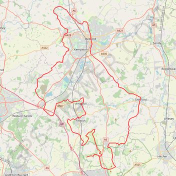
Name: Route GPS track, route, trail
Coordinates: 51.92538 -0.61265 52.18811 -0.33532
Other GPS tracks
Click on a GPS track to view route, its statistics and profile.
Deacon Hill
United Kingdom > England > Hertfordshire > North Hertfordshire
Letchworth, Ickleford, Pirton, Deacon Hill and return
Distance: 26.5 Km • Elevation gain: 293 m • Maximum elevation: 182 m