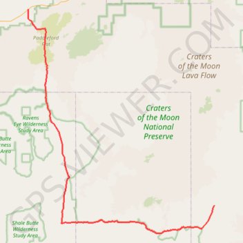
Craters of the Moon roads
Craters of the Moon National Preserve. #Nature #Desert
- Distance: 89.4 Km
- Elevation gain: 416 m
- Maximum elevation: 1,488 m
- Elevation loss: 451 m
- Minimum elevation: 1,301 m
- Moving time: 2 h 47 m
- Moving speed: 32.0 Km/h
- Maximum speed: 68.2 Km/h
- Total time: 2 h 52 m
- Global speed: 31.2 Km/h
- Date: Sunday, February 11, 2024
Interactive map
GPS track profile
About this GPS track
Name: Craters of the Moon roads GPS track, route, trail
Start: US 93;US 20;US 26, Blaine County, Idaho, 83320, United States (43.35771 -113.83712)
End: Blaine County, Idaho, United States (42.98409 -113.35170)
Coordinates: 42.92993 -113.83760 43.35771 -113.35125