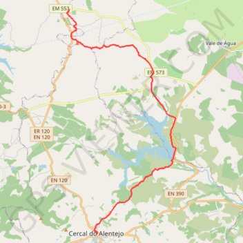
Rota Vicentina - Chemin historique - Étape 2
Vale Seco » Cercal do Alentejo
- Distance: 22.6 Km
- Elevation gain: 288 m
- Maximum elevation: 207 m
- Elevation loss: 314 m
- Minimum elevation: 105 m
Interactive map
GPS track profile
About this GPS track
Name: Rota Vicentina - Chemin historique - Étape 2 GPS track, route, trail
Coordinates: 37.80036 -8.69314 37.92235 -8.61801
Other GPS tracks
Click on a GPS track to view route, its statistics and profile.
Southern section — European Divide Trail
France > Auvergne-Rhône-Alpes > Drôme > Valence
Distance: 2,423.8 Km • Elevation gain: 42,375 m • Maximum elevation: 2,005 m
Eurovelo 01 Spain + Portugal
France > Nouvelle-Aquitaine > Pyrénées-Atlantiques > Hendaye
Distance: 3,107.2 Km • Elevation gain: 30,592 m • Maximum elevation: 1,503 m
Stage 26: Valence to Saint-Jean-de-Fos — European Divide Trail
France > Auvergne-Rhône-Alpes > Drôme > Valence
Distance: 2,423.8 Km • Elevation gain: 42,375 m • Maximum elevation: 2,005 m
MaRotaVicentina
Portugal > Beja > Odemira > Bemposta de Cima
Distance: 137.1 Km • Elevation gain: 2,639 m • Maximum elevation: 289 m
Stage 26: Valence to Saint-Jean-de-Fos — European Divide Trail
Distance: 859.0 Km • Elevation gain: 16,438 m • Maximum elevation: 1,490 m
Vila do Bispo -> Distrito 4 (495,2 km)
Distance: 1,306.4 Km • Elevation gain: 23,128 m • Maximum elevation: 2,134 m