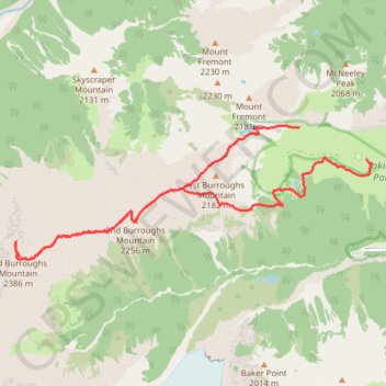
Hiking out to 3rd Burroughs Mountain near Rainier
- Distance: 14.4 Km
- Elevation gain: 751 m
- Maximum elevation: 2,383 m
- Elevation loss: 881 m
- Minimum elevation: 1,874 m
- Moving time: 4 h 21 m
- Moving speed: 3.3 Km/h
- Maximum speed: 37.4 Km/h
- Total time: 6 h 5 m
- Global speed: 2.4 Km/h
- Date: Monday, July 17, 2023
Interactive map
GPS track profile
About this GPS track
Name: Hiking out to 3rd Burroughs Mountain near Rainier GPS track, route, trail
Start: Sourdough Ridge Trail, Sunrise, Pierce County, Washington, United States (46.91936 -121.65630)
End: Sunrise Park Road, Sunrise, Pierce County, Washington, United States (46.91428 -121.64205)
Coordinates: 46.90090 -121.71413 46.91949 -121.64177
Other GPS tracks
Click on a GPS track to view route, its statistics and profile.
Northern part of the Pacific Crest Trail (PCT)
United States > Oregon > Klamath County
Hike on the Pacific Crest National Scenic Trail from Crater Lake to Canada Border through Oregon and Washington along the Sierra Nevada and Cascade mountain ranges. #Hike #Mountain #SierraNevada #Cascade #Nature #Forest #Park #PCT
Distance: 1,198.3 Km • Elevation gain: 44,308 m • Maximum elevation: 2,307 m