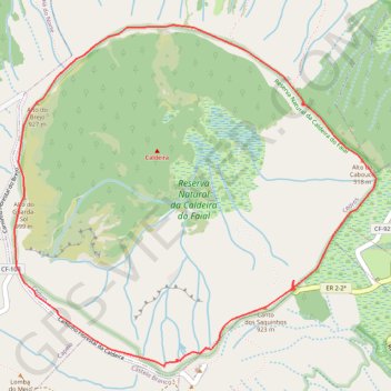
Faial Caldeira circle trail
- Distance: 7.0 Km
- Elevation gain: 322 m
- Maximum elevation: 1,020 m
- Elevation loss: 322 m
- Minimum elevation: 852 m
- Moving time: 2 h 53 m
- Moving speed: 2.4 Km/h
- Maximum speed: 4.6 Km/h
- Total time: 2 h 59 m
- Global speed: 2.3 Km/h
- Date: Saturday, August 31, 2019
Interactive map
GPS track profile
About this GPS track
Name: Faial Caldeira circle trail GPS track, route, trail
Start: PRC 01 FAI, Ramal para a Caldeira, Flamengos, Horta, Açores, 9900, Portugal (38.58043 -28.70641)
Coordinates: 38.57622 -28.72608 38.59497 -28.70068
Other GPS tracks
Click on a GPS track to view route, its statistics and profile.
Açores, Faial: Levada
Distance: 14.4 Km • Elevation gain: 710 m • Maximum elevation: 997 m
Trail Planner Map
Distance: 3.0 Km • Elevation gain: 347 m • Maximum elevation: 901 m
Praia do Norte
Randonnée pédestre. En aller simple. #Randonnée
Distance: 10.1 Km • Elevation gain: 134 m • Maximum elevation: 924 m