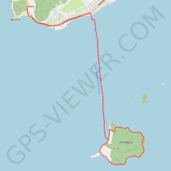
L'île du Lapin
Randonnée depuis Krong Kaeb. #Randonnée
- Distance: 13.6 Km
- Elevation gain: 98 m
- Maximum elevation: 28 m
- Elevation loss: 123 m
- Minimum elevation: 0 m
- Moving time: 2 h 32 m
- Moving speed: 5.3 Km/h
- Maximum speed: 36.1 Km/h
- Total time: 3 h 25 m
- Global speed: 4.0 Km/h
- Date: Friday, March 29, 2013
Interactive map
GPS track profile
About this GPS track
Name: L'île du Lapin GPS track, route, trail
Start: Kep, 220201, Cambodge (10.48262 104.29581)
End: National Road 33A, Kep, 012345, Cambodge (10.43803 104.32110)
Coordinates: 10.42981 104.29356 10.48262 104.33321