ACTIVE LOG
- Distance: 4.3 Km
- Elevation gain: 125 m
- Maximum elevation: 625 m
- Elevation loss: 639 m
- Minimum elevation: 69 m
- Moving time: 1 h 13 m
- Moving speed: 3.5 Km/h
- Maximum speed: 6.3 Km/h
- Total time: 1 h 24 m
- Global speed: 3.1 Km/h
- Date: Thursday, May 02, 2013
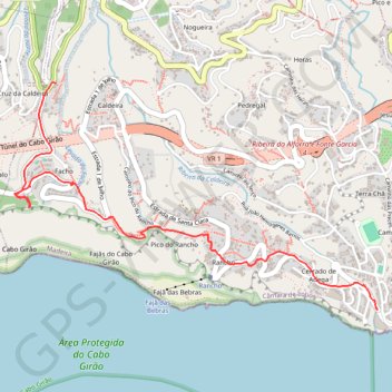
Interactive map
GPS track profile
About this GPS track
Name: ACTIVE LOG GPS track, route, trail
Start: Levada do Norte, Cruz da Caldeira, Câmara de Lobos, Madère, 9300-401, Portugal (32.66323 -17.00271)
Coordinates: 32.65084 -17.00541 32.66327 -16.98188
Other GPS tracks
Click on a GPS track to view route, its statistics and profile.
Passeio aniversario nsr
Route created on plotaroute.com
Distance: 59.3 Km • Elevation gain: 3,095 m • Maximum elevation: 1,089 m
Madère - Cabo Girao
Randonnée entre Câmara de Lobos et Funchal. #Randonnée
Distance: 7.4 Km • Elevation gain: 255 m • Maximum elevation: 625 m
04 camara de lobos to cabo girao
Portugal > Câmara de Lobos > Estreito de Câmara de Lobos > Castelejo
Distance: 5.2 Km • Elevation gain: 137 m • Maximum elevation: 600 m