Madère - Cabo Girao
Randonnée entre Câmara de Lobos et Funchal. #Randonnée
- Distance: 7.4 Km
- Elevation gain: 255 m
- Maximum elevation: 625 m
- Elevation loss: 801 m
- Minimum elevation: 0 m
- Moving time: 1 h 52 m
- Moving speed: 3.9 Km/h
- Maximum speed: 10.2 Km/h
- Total time: 2 h 8 m
- Global speed: 3.5 Km/h
- Date: Thursday, May 02, 2013
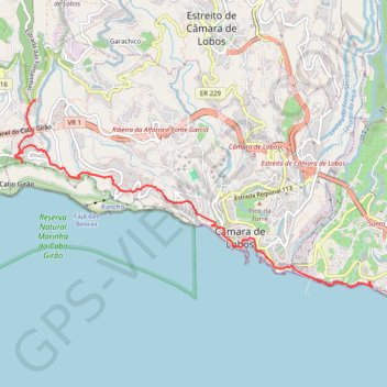
Interactive map
GPS track profile
About this GPS track
Name: Madère - Cabo Girao GPS track, route, trail
Start: Levada do Norte, Cruz da Caldeira, Câmara de Lobos, Madère, 9300-401, Portugal (32.66323 -17.00271)
Coordinates: 32.64291 -17.00541 32.66327 -16.95916
Other GPS tracks
Click on a GPS track to view route, its statistics and profile.
Promenade Lido
Randonnée entre Funchal et Câmara de Lobos. #Randonnée
Distance: 6.3 Km • Elevation gain: 248 m • Maximum elevation: 73 m
04 camara de lobos to cabo girao
Portugal > Câmara de Lobos > Estreito de Câmara de Lobos > Castelejo
Distance: 5.2 Km • Elevation gain: 137 m • Maximum elevation: 600 m
ACTIVE LOG
Distance: 4.3 Km • Elevation gain: 125 m • Maximum elevation: 625 m