Cathedral Rock
Interactive map
GPS track profile
About this GPS track
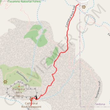
Name: Cathedral Rock GPS track, route, trail
Start: Cathedral Rock Trail, Yavapai County, Arizona, 86336, United States (34.82517 -111.78862)
End: Cathedral Rock Trail, Yavapai County, Arizona, 86336, United States (34.82518 -111.78860)
Coordinates: 34.81877 -111.79229 34.82518 -111.78860
Other GPS tracks
Click on a GPS track to view route, its statistics and profile.
Cathedral Rock Loop
United States > Arizona > Coconino County
Loop hike to Cathedral Rock Viewpoint via Slim Shady Trail, Templeton Trail, Cathedral Rock Trail, Oak Creek, Baldwin Trail, Hiline Trail and Yavapai Vista in the Coconino National Forest. #Hike #Loop #Rock #Nature #Forest #River #Mountain
Distance: 14.4 Km • Elevation gain: 684 m • Maximum elevation: 1,472 m