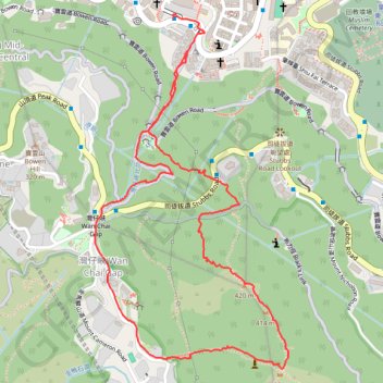
金馬倫北坑 金馬倫西坑
- Distance: 4.0 Km
- Elevation gain: 340 m
- Maximum elevation: 399 m
- Elevation loss: 347 m
- Minimum elevation: 67 m
- Moving time: 1 h 20 m
- Moving speed: 2.9 Km/h
- Maximum speed: 18.9 Km/h
- Total time: 2 h 52 m
- Global speed: 1.4 Km/h
- Date: Saturday, March 02, 2024
Interactive map
GPS track profile
About this GPS track
Name: 金馬倫北坑 金馬倫西坑 GPS track, route, trail
Coordinates: 22.26320 114.16985 22.27384 114.17613
Topography: Hong Kong Island topographic map
Other GPS tracks
Click on a GPS track to view route, its statistics and profile.
Hong Kong island ride
China > Hong Kong > Hong Kong Island
#Bike
Distance: 61.8 Km • Elevation gain: 2,152 m • Maximum elevation: 505 m
Wilson Trail Full Route
China > Hong Kong > Hong Kong Island
Distance: 81.2 Km • Elevation gain: 4,430 m • Maximum elevation: 613 m
Trail Planner Map
China > Hong Kong > Hong Kong Island
Distance: 20.3 Km • Elevation gain: 1,151 m • Maximum elevation: 423 m