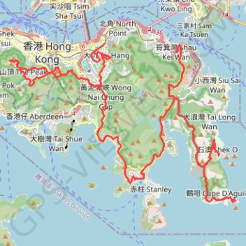
Hong Kong island ride
#Bike
- Distance: 61.8 Km
- Elevation gain: 2,152 m
- Maximum elevation: 505 m
- Elevation loss: 2,152 m
- Minimum elevation: 3 m
Interactive map
GPS track profile
About this GPS track
Name: Hong Kong island ride GPS track, route, trail
Coordinates: 22.20762 114.14363 22.28286 114.26014
Topography: Hong Kong Island topographic map
Other GPS tracks
Click on a GPS track to view route, its statistics and profile.
HK dino
China > Hong Kong > Hong Kong Island
Loop hike from Kennedy Town via Lung Fu Shan, High West, Victoria Peak, Pok Fu Lam Reservoir and Mount Davis in the Lung Fu Shan Country Park and the Pok Fu Lam Country Park. #Hike #Loop #Nature #Mountain #Forest #Sea #Pacific #Ocean #Park
Distance: 24.4 Km • Elevation gain: 1,325 m • Maximum elevation: 529 m
Central Hong Kong - Pok Fu Lam Country Park
China > Hong Kong > Hong Kong Island
#Hike
Distance: 7.4 Km • Elevation gain: 431 m • Maximum elevation: 401 m
Wilson Trail
China > Hong Kong > Hong Kong Island
#Hike
Distance: 13.1 Km • Elevation gain: 1,032 m • Maximum elevation: 410 m
Jardine's Lookout
China > Hong Kong > Hong Kong Island
#Hike
Distance: 6.1 Km • Elevation gain: 350 m • Maximum elevation: 410 m
薑花石澗右源 奇薄坑 薄扶林東坑
China > Hong Kong > Hong Kong Island
Hong Kong Island Hike
Distance: 5.5 Km • Elevation gain: 260 m • Maximum elevation: 429 m
荷兰径
China > Hong Kong > Hong Kong Island
Outdoor walk
Distance: 8.6 Km • Elevation gain: 718 m • Maximum elevation: 333 m
打石石澗
China > Hong Kong > Hong Kong Island
Outdoor hiking
Distance: 1.3 Km • Elevation gain: 149 m • Maximum elevation: 204 m
雙潭渣大
China > Hong Kong > Hong Kong Island
Distance: 6.8 Km • Elevation gain: 353 m • Maximum elevation: 305 m
金馬倫北坑 金馬倫西坑
China > Hong Kong > Hong Kong Island
Distance: 4.0 Km • Elevation gain: 340 m • Maximum elevation: 399 m
Trail Planner Map
China > Hong Kong > Hong Kong Island
Distance: 20.3 Km • Elevation gain: 1,151 m • Maximum elevation: 423 m
Wilson Trail Full Route
China > Hong Kong > Hong Kong Island
Distance: 81.2 Km • Elevation gain: 4,430 m • Maximum elevation: 613 m
Parview - Mont Butler - Reservoirs - Repulse Bay
Chine > Hong Kong > Île de Hong Kong
Randonnée pédestre. En aller simple. #Randonnée
Distance: 8.4 Km • Elevation gain: 382 m • Maximum elevation: 410 m