HK dino
Loop hike from Kennedy Town via Lung Fu Shan, High West, Victoria Peak, Pok Fu Lam Reservoir and Mount Davis in the Lung Fu Shan Country Park and the Pok Fu Lam Country Park. #Hike #Loop #Nature #Mountain #Forest #Sea #Pacific #Ocean #Park
- Distance: 24.4 Km
- Elevation gain: 1,325 m
- Maximum elevation: 529 m
- Elevation loss: 1,349 m
- Minimum elevation: 6 m
- Moving time: 6 h 14 m
- Moving speed: 3.9 Km/h
- Maximum speed: 15.4 Km/h
- Total time: 7 h 7 m
- Global speed: 3.4 Km/h
- Date: Saturday, March 09, 2024
Interactive map
GPS track profile
About this GPS track
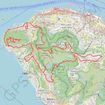
Name: HK dino GPS track, route, trail
Coordinates: 22.25868 114.11731 22.28406 114.16195
Topography: Hong Kong Island topographic map
Other GPS tracks
Click on a GPS track to view route, its statistics and profile.
Central Hong Kong - Pok Fu Lam Country Park
China > Hong Kong > Hong Kong Island
#Hike
Distance: 7.4 Km • Elevation gain: 431 m • Maximum elevation: 401 m
Hong Kong island ride
China > Hong Kong > Hong Kong Island
#Bike
Distance: 61.8 Km • Elevation gain: 2,152 m • Maximum elevation: 505 m
薑花石澗右源 奇薄坑 薄扶林東坑
China > Hong Kong > Hong Kong Island
Hong Kong Island Hike
Distance: 5.5 Km • Elevation gain: 260 m • Maximum elevation: 429 m
荷兰径
China > Hong Kong > Hong Kong Island
Outdoor walk
Distance: 8.6 Km • Elevation gain: 718 m • Maximum elevation: 333 m
Trail Planner Map
China > Hong Kong > Hong Kong Island
Distance: 20.3 Km • Elevation gain: 1,151 m • Maximum elevation: 423 m
Wilson Trail Full Route
China > Hong Kong > Hong Kong Island
Distance: 81.2 Km • Elevation gain: 4,430 m • Maximum elevation: 613 m